 My GeoNetwork catalogue
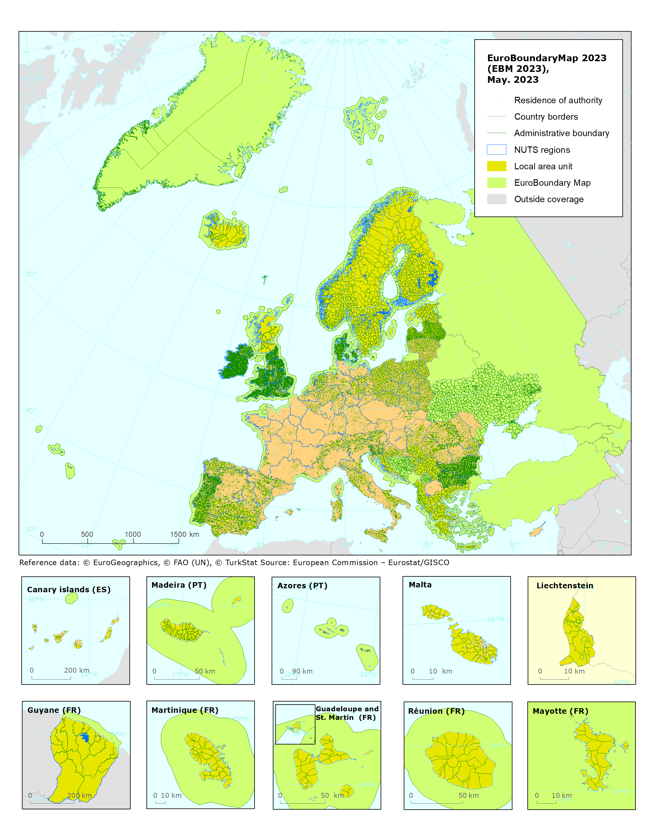
EuroBoundaryMap 2023 (EBM 2023), May 2023
EuroBoundaryMap provides a European geographic database for administrative and statistical regions that will be maintained at the source level by the National Mapping and Cadastral Agencies (NMCAs), and by providing harmonized access conditions for this geographic information within the framework of EuroGeographics. EBM (1:100000) offers the combined strength of detailed European administrative units and linkages to the corresponding LAU and NUTS codes.
This metadata refers to the EBM 2023 which is a completely new update of the EuroBoundaryMap product, based on the new NUTS 2022 regulation. The basis for the update was the previous release EBM 2022, which was released officially by EuroGeographics in January 2022. The dataset is provided both in a full Europe dataset (Data_FullEurope) and divided by countries (Data_Countries) in GDB - and GPKG formats.
EBM 2023 contains the matching with the NUTS regulations No 2019/1755 (NUTS 2022) and refers to the administrative situation as it was in each country on 31 December 2021 (reference date).
IMPORTANT NOTE: This data set is only to be used internally in the EEA, for the purposes and under the conditions stated under the "Resource Constraints" elements of this metadata file and on the document "LicenseConditions_EBM.pdf" provided with this dataset under "Documentation" link. This metadata has been slightly adapted from the original metadata file provided by EuroGeographics and is to be used only for internal EEA purposes. For reference, the metadata file created by EuroGeographics is provided together with the dataset ("EBM_2023_EC_Metadata.xml" within the "Descriptions_Metadata") as well as the national metadata stored under each corresponding country folder in "Descriptions_Metadata" provided together with the dataset under the link "Documentation".
Simple
- Date (Publication)
- 2023-05-18
- Date (Creation)
- 2022-12-01
- Edition
-
17.00
- Citation identifier
- eurogeographics_v_4258_100_k_ebm_i_2021_v17_r00
- Status
- superseded
Point of contact
Point of contact
Point of contact
Point of contact
- Maintenance and update frequency
- Annually
-
GEMET
-
-
sub-national boundary
-
administrative boundary
-
national boundary
-
- Keywords
-
- Keywords
-
-
Continents, countries, sea regions of the world.
-
-
Andorra
-
EFTA4
-
Serbia
-
United Kingdom
-
Bosnia and Herzegovina
-
Greenland
-
Moldova
-
Ukraine
-
Albania
-
San Marino
-
Faeroe Islands
-
Kosovo (UNSCR 1244/99)
-
Gibraltar
-
Monaco
-
Vatican
-
EU27 (from 2020)
-
North Macedonia
-
- Access constraints
- Other restrictions
- Use constraints
- Other restrictions
- Other constraints
-
INTELLECTUAL PROPERTY RIGHTS: The Commission is authorized to distribute derived geographic data and other derived products, if
(1) The original geometry is generalised to the equivalent of a scale of 1:3000000 or smaller, applying the same quality principles in terms of resolution and accuracy as for the original geographic data or if the content of information in terms of number of features is less or equal to 20% of the number of features in the original geographic data (for the data extent relevant to the data to be distributed),
(2) The data is not used for commercial purpose and,
(3) The source is acknowledged.
The acknowledgement to include when using this specific data set is: "Administrative boundaries: ©EuroGeographics". More information about the acknowledgement of the source or metadata is given in the document "LicenseConditions_EBM.pdf" provided with the dataset.
- Aggregate Datasetindentifier
- 0832155a-f0af-4ab5-9555-bb6c7b92e379
- Association Type
- revisionOf
- Spatial representation type
- Vector
- Denominator
- 100000
- Language
- alb
- Language
- arm
- Language
- aze
- Language
- baq
- Language
- bel
- Language
- bos
- Language
- bul
- Language
- Catalan; Valencian
- Language
- cze
- Language
- Dansk
- Language
- dsb
- Language
- Nederlands; Vlaams
- Language
- English
- Language
- est
- Language
- fao
- Language
- Finnish
- Language
- Français
- Language
- frr
- Language
- fry
- Language
- geo
- Language
- Deutsch
- Language
- gla
- Language
- gle
- Language
- glv
- Language
- gre
- Language
- hrv
- Language
- hsb
- Language
- hun
- Language
- ice
- Language
- Italiano
- Language
- kal
- Language
- lat
- Language
- lav
- Language
- lit
- Language
- ltz
- Language
- mlt
- Language
- Norwegian
- Language
- Polish
- Language
- Portuguese
- Language
- roh
- Language
- rum
- Language
- Russian
- Language
- Slovak [SK]
- Language
- slv
- Language
- sma
- Language
- sme
- Language
- smi
- Language
- smj
- Language
- Spanish; Castilian
- Language
- srp
- Language
- Swedish
- Language
- Turkish
- Language
- ukr
- Language
- wel
- Character set
- UTF8
- Character set
- UTF8
- Character set
- UTF8
- Character set
- UTF8
- Character set
- UTF8
- Character set
- UTF8
- Character set
- UTF8
- Character set
- UTF8
- Character set
- UTF8
- Character set
- UTF8
- Character set
- UTF8
- Character set
- UTF8
- Character set
- UTF8
- Character set
- UTF8
- Character set
- UTF8
- Character set
- UTF8
- Character set
- UTF8
- Character set
- UTF8
- Character set
- UTF8
- Character set
- UTF8
- Character set
- UTF8
- Character set
- UTF8
- Character set
- UTF8
- Character set
- UTF8
- Character set
- UTF8
- Character set
- UTF8
- Character set
- UTF8
- Character set
- UTF8
- Character set
- UTF8
- Character set
- UTF8
- Character set
- UTF8
- Character set
- UTF8
- Character set
- UTF8
- Character set
- UTF8
- Character set
- UTF8
- Character set
- UTF8
- Character set
- UTF8
- Character set
- UTF8
- Character set
- UTF8
- Character set
- UTF8
- Character set
- UTF8
- Character set
- UTF8
- Character set
- UTF8
- Character set
- UTF8
- Character set
- UTF8
- Character set
- UTF8
- Character set
- UTF8
- Character set
- UTF8
- Character set
- UTF8
- Character set
- UTF8
- Character set
- UTF8
- Character set
- UTF8
- Character set
- UTF8
- Character set
- UTF8
- Topic category
-
- Environment
))
- Begin date
- 2022-01-01
- End date
- 2022-12-31
- Supplemental Information
-
Names of administrative units and levels are stored with Unicode character set as well as standard ASCII. Considering the user requirements, it can also be distinguished between land and water parts of administrative units within EuroBoundaryMap.Territorial sea areas are included for a number of countries as an optional feature. This comprises territorial waters assigned to administrative units on lowest national level as well as territorial waters, which are directly administered by the national government. The definition of the territorial sea strictly follows the United Nations Convention on the Law of the Sea. All territorial sea areas are attributed as coastal waters.
For more information about the data product specifications and changes with respect to the previous version of this dataset (EBM 2023), please refer to the documents EBM_2023_Specification.pdf and EBM_2023_Changes.pdf provided with the data set under the folder "Documents" and "Descriptions_Metadata" under "Documentation" link.
Former versions of EBM Full Europe database contained overlapping datasets. Kosovo was already integrated in EBM as provided by an own agency of the independent country. The Serbian dataset did also cover Kosovo. Due to the Serbian legal position, this territory is part of Serbia. The Serbian LAU/NUTS table contains Kosovo as an autonomous region of Serbia. The EBM_2023 Full Europe database does now contain Kosovo (KS) as provided by the agency of the independent country. The following statement has to be respected:
"This designation is without prejudice to positions on status, and is in line with UNSCR 1244 and the ICJ Opinion on the Kosovo Declaration of Independence".
- Unique resource identifier
- EPSG:4258
- Distribution format
-
Name Version GDB
Geopackage
OnLine resource
OnLine resource
- Hierarchy level
- Dataset
Domain consistency
Conformance result
- Date (Publication)
- 2010-12-08
- Explanation
-
See the referenced specification
Conformance result
- Title
-
EBM 2023 Specification
- Date (Publication)
- 2023-05-01
- Statement
-
Delivered separately for each national contribution.
Please refer to the documents "XX_EBM_2022_Lineage.pdf" (where XX is the country acronym), stored under each corresponding country folder in "Descriptions_Metadata" provided together with the dataset under the link "Documentation".
Metadata
- File identifier
- b97c1f77-dce5-4c68-9b65-00c36c157737 XML
- Metadata language
- English
- Character set
- MD_CharacterSetCode_utf8
- Hierarchy level
- Dataset
- Date stamp
- 2025-10-09T11:11:02.780335Z
- Metadata standard name
-
ISO 19115-3:2018
- Metadata standard version
-
1.0
- Metadata author
-
Organisation name Individual name Electronic mail address Role European Environment Agency
Point of contact
)))
